
Thermography in Solar Panels: Efficient Preventive Maintenance

Thermography applied to solar panels is an essential technique to guarantee the correct operation and efficiency of photovoltaic installations. If you want to ensure that your solar panels are operating at peak performance and avoid potential failures, a thermographic inspection is the way to go. In this article, we will explore what solar panel thermography is, its benefits, the technologies used and how it is applied in different industrial sectors. What is Thermography in Solar Panels? Solar panel thermography is an inspection technique that uses infrared cameras to measure and visualize temperatures on the surfaces of photovoltaic modules. These cameras capture the thermal radiation emitted by objects, making it possible to identify hot spots or thermal anomalies that may indicate faults or performance problems. The great advantage of this technique is that it does not require physical contact with the panels and allows inspections to be performed quickly and accurately, even in large installations. Thermography is key to detecting problems such as: Damaged or defective cells. Hot spots that reduce panel efficiency. Loose or deteriorated connections. Partial shadows affecting performance. Accumulated dirt blocking solar radiation. Practical Application in Infrastructure Inspections Aerolaser offers advanced thermographic inspection solutions for critical infrastructure. Thanks to thermographic cameras mounted on drones such as DJI Zenmuse H20T and Zenmuse X5S, accurate aerial inspections are performed and anomalies in large solar installations are quickly detected. This technology makes it possible to identify problems before they become critical failures, optimizing efficiency and reducing risks. Importance of Predictive Maintenance in Photovoltaic Installations Predictive maintenance is a strategy that consists of detecting potential failures before they occur, allowing repairs to be planned efficiently and avoiding unplanned downtime. In solar installations, this is essential to ensure that the panels operate at peak performance throughout their lifetime. With thermography, it is possible to identify problems that would go unnoticed with the naked eye. This not only helps to maintain the efficiency of the panels, but also: Reduces the risk of fires caused by undetected hot spots. Minimizes repair costs by acting before failures become serious. Optimize downtime by planning maintenance interventions in advance. Regular thermographic inspections save time and money by preventing catastrophic failures and prolonging the life of PV systems. Benefits of Thermographic Inspection of Solar Panels Thermography offers multiple advantages for solar panel maintenance. Early Detection of Anomalies Thanks to the ability to capture thermal images, it is possible to identify problems such as hot spots or faulty cells at an early stage, before they seriously affect system performance. Fast and Efficient Inspection Thermography makes it possible to inspect large areas in a short time. Using drones with thermographic cameras, installations of several square kilometers can be covered without the need to manually move around each panel. 3. No Service Interruption Thermographic inspections are performed without the need to disconnect the solar panels, which means that energy production is not interrupted during the process. 4. Risk Prevention Identifying hot spots and overheated components helps prevent fires and serious failures that could put the entire installation at risk. How Infrared Thermography Works for Fault Detection The infrared thermography is based on the detection of thermal radiation emitted by objects. Each cell in a solar panel emits heat proportional to its performance. When a cell develops a fault, its temperature can be significantly higher or lower than the surrounding cells, which is reflected in a thermal image as a hot or cold spot. Inspection Process Thermal imaging with infrared cameras from the ground or by drones. Image analysis to identify abnormal patterns. Generation of reports with the exact locations of anomalies and maintenance recommendations. Aerolaser uses the DALIA platform to efficiently manage and analyze inspection data, prioritizing anomalies according to their severity. Technologies Used in Thermography of Solar Panels The accuracy of a thermographic inspection depends largely on the technology used. Some of the most common tools include: Portable thermal imaging cameras: Ideal for spot inspections in small installations. Drones with thermographic cameras: Perfect for quick and detailed inspections in large solar plants. Thermal analysis software: Tools such as the DALIA platform make it possible to analyze and manage large volumes of thermal data. State-of-the-Art Aerolaser Technology In the inspections, DJI Zenmuse H20T and Zenmuse X5S cameras mounted on drones are used to capture thermal images from the air. This technology allows the camera direction to be controlled in real time, ensuring complete coverage of the facility and unparalleled accuracy. Common Cases of Failures Detected by Thermography Some of the most frequent problems detected in the inspections include: Hot spots due to damaged or shaded cells. Disconnection of bypass diodes, resulting in local overheating. Faulty connections in the inverters or wiring. Accumulated dirt that reduces the efficiency of the panel. Identifying these faults in time allows quick action to be taken and prevents efficiency losses and major damage. Conclusion: Optimize the Efficiency and Safety of Your Solar Panels Thermography in solar panels is an indispensable tool to ensure preventive maintenance and efficiency of photovoltaic installations. Thanks to this technique, it is possible to detect failures before they become serious problems, reducing costs and optimizing performance. If you are interested in learning more, visit our thermography service. At Aerolaser, thermographic inspections are an investment that translates into significant savings, increased safety and longer solar panel life. If you are looking to keep your installations in optimal conditions, thermography is the key to achieve it. Trust Aerolaser to ensure maximum performance and safety of your solar panels!
What is Building Thermography and what is it for?

Building thermography is an inspection technique that uses thermal cameras to identify temperature patterns in structures, helping to detect problems such as air leaks, dampness, defective insulation and electrical faults. This non-invasive technology is essential for optimizing energy efficiency and preventing serious structural damage. Aerolaser uses high-precision cameras such as the DJI Zenmuse H20T and Zenmuse X5S, tools that capture thermal images with an exceptional level of detail. Thanks to these technologies, it is possible to perform a comprehensive analysis without the need for destructive interventions. From our experience, we have solved critical problems in key infrastructures, identifying hot spots in electrical systems before they lead to serious failures. How Does Infrared Thermography Work in Buildings? Principles of thermography in buildings Infrared thermography measures the thermal radiation emitted by surfaces and translates it into thermal images. These images reveal temperature variations that can indicate anomalies. For example, cooler areas may indicate water infiltration, while hot areas could indicate air leaks or overheating in electrical systems. Specific benefits of thermography in buildings This method allows us to detect problems before they become visible to the human eye or cause major damage. In a recently inspected residential building, we were able to identify thermal bridges responsible for increased energy costs and recommend immediate solutions that resulted in significant savings. At Aerolaser, we use advanced technologies such as the Zenmuse H20T cameras, which combine thermal and optical sensors, and the Zenmuse X5S, ideal for capturing detailed images from complex angles. This allows us to obtain accurate data even in challenging conditions, such as high altitudes or adverse weather. Applications of Thermography in Building Inspection Identification of energy losses One of the most common applications of thermography is to locate areas where energy is lost, such as poorly sealed windows or inadequately insulated walls. This is crucial for improving the energy efficiency of any building. Moisture and leak detection Thermal cameras can identify changes in the temperature of surfaces affected by moisture even before visible stains appear. This approach enables quick repairs and prevents major structural damage. Inspection of electrical systems Thermography detects hot spots in transformers, electrical panels and other critical components, reducing the risk of failure and improving the safety of installations. Benefits of Thermographic Inspection for Energy Efficiency Using thermography in buildings not only solves existing problems, but also optimizes energy performance. By identifying problem areas, it is possible to implement improvements that reduce energy consumption and operating costs. In commercial buildings, this can translate into considerable savings in the long term, in addition to meeting sustainability standards. Professional Thermographic Inspection Procedure The process includes pre-planning, capturing thermal images with high-precision equipment such as Zenmuse cameras, and interpreting the results to generate a detailed report. This report is key to making data-driven decisions and prioritizing necessary repairs or adjustments. If you are looking for a company that specializes in thermography services, contact us for more information on how we can help you.
Industrial Thermography: Key Technology for Predictive Maintenance

Industrial thermography has established itself as an essential tool in the management and maintenance of critical infrastructures. At Aerolaser, we have integrated this cutting-edge technology to offer accurate, safe and highly efficient thermal inspections, helping our customers to optimize their systems and prevent failures before they become serious problems. What is Industrial Thermography? Industrial thermography is a technique that uses infrared cameras to capture and measure the thermal radiation emitted by objects. This method allows remote, non-contact temperature assessment, providing thermal images that reveal anomalies in real time. At Aerolaser, we use this approach to detect hot spots, electrical and mechanical failures, and other problems invisible to the human eye, optimizing the performance of equipment and systems in a wide variety of industries. Infrared Thermography Principles of Operation The operation of infrared thermography is based on the ability of objects to emit thermal radiation. Thermal imaging cameras convert this radiation into visual images showing temperature variations. These images make it possible to quickly identify areas with anomalous temperatures, a clear sign of possible failure or overheating. At Aerolaser, we use gimbal manufactured by Trakka, specifically the SWE300 and SWE400 models, for our thermographic inspections on aircraft. These devices integrate high-precision thermal cameras and additional sensors that can vary depending on the model, allowing us to perform complete inspections tailored to each need. Thanks to the gimbal design, it is possible to control the direction of the equipment from inside the aircraft, ensuring comprehensive and accurate coverage of critical infrastructure. Thermography Applications in Industrial Maintenance Inspection of Electrical and Mechanical Systems Electrical and mechanical systems are essential for the operation of any industrial facility. Thermography can identify overheating in components such as transformers, insulators and electric motors, preventing critical failures. Aerolaser specializes in comprehensive inspections, capturing high-resolution thermal images that help make informed maintenance decisions. Hot Spot and Thermal Anomaly Detection Detecting hot spots is crucial to prevent fires and ensure the safety of installations. Our advanced technology makes it possible to identify these risks before they cause significant disruptions or damage. Predictive and Preventive Maintenance Thermography facilitates effective predictive maintenance by anticipating failures in critical equipment. With our solutions, companies can plan repairs in advance, minimizing downtime and optimizing resources. Advantages of Implementing Thermography in Industry Safety and Failure Prevention Safety is a priority in any industrial facility, and thermography is a key tool for maintaining it. By detecting problems before they become critical hazards, this technology enables companies to mitigate potential failures in electrical, mechanical or structural systems. For example, a thermographic inspection can identify overheating in electrical connections that could lead to short circuits or fires. In addition, this preventative capability significantly reduces risks to personnel, minimizing exposure to accidents and improving overall workplace safety. Energy Efficiency Optimization Thermography not only identifies faults, but is also essential for improving the energy efficiency of installations. Detecting thermal leaks in insulation systems, heat losses in pipes or critical points in energy equipment allows adjustments to be made to optimize energy consumption. These improvements not only benefit operational performance, but also contribute to reducing environmental impact, aligning with the sustainability initiatives of many companies. In a market increasingly focused on energy efficiency and savings, these solutions are a key competitive advantage. Reduction of Operating Costs Problems not detected in time often result in costly repairs and unplanned interruptions to operations. Thermography enables companies to implement a proactive approach, planning repairs or maintenance before a failure causes major damage. This predictive approach not only reduces expenses related to emergency interventions, but also extends equipment life and improves overall productivity. For example, a periodic inspection can prevent the premature replacement of a transformer, saving significant costs and ensuring uninterrupted operations. Technologies and Equipment Used by Aerolaser At Aerolaser, we have developed a comprehensive strategy for our thermographic inspections, combining state-of-the-art technologies: Trakka SWE300 and SWE400 Gimbal: Designed for large-scale aerial inspections, these units integrate high-precision thermal cameras capable of detecting hot spots in critical infrastructure. Additional sensors vary by model, providing advanced capabilities for each mission. Aircraft control: The gimbal technology allows controlling the direction of the equipment from inside the aircraft, ensuring a complete and efficient inspection of the assigned areas. Our ability to integrate these teams ensures optimal results, regardless of the complexity of the project. Considerations for Thermography Implementation Implementing a thermographic inspection system requires considering aspects such as equipment calibration, operator training and integration with other management technologies. Aerolaser accompanies its customers in this process, ensuring that each solution is perfectly adapted to the needs of their industry. Aerolaser, your Partner in Industrial Thermography Industrial thermography is not only an innovative technology, but a necessity for any industry seeking efficiency, safety and sustainability. At Aerolaser, we combine experience, innovation and a customer-centric approach to deliver solutions that make a difference. Trust Aerolaser to protect your infrastructure and optimize the performance of your systems with world-class thermographic services. Contact us to discover how our solutions can transform your operations.
Infrared Thermography: The Key Tool for Inspection

What is infrared thermography and why is it essential? The infrared thermography has become an essential technology in the analysis of infrastructures, electrical systems and industrial inspections. This technique makes it possible to visualize the thermal radiation emissions of objects and translate them into images reflecting temperature variations. From detecting hot points to identifying incipient failures in critical equipment, thermography is a non-invasive and extremely accurate tool. Its ability to prevent accidents and optimize processes positions it as a versatile solution for multiple industries. How infrared thermography works Infrared thermography uses special cameras capable of capturing the infrared radiation emitted by all objects. These cameras convert the radiation into thermal images where temperatures are represented by different colors: warm tones for high temperatures and cold tones for lower temperatures. Non-contact inspection: Allows analysis in operating equipment or locations that are difficult to access. Colors and temperature: Depicts thermal variations in images to quickly identify problems. Advanced technology: Devices such as the DJI Zenmuse H20T and Zenmuse X5S cameras offer unmatched accuracy from the air, ensuring complete diagnostics even in the most demanding conditions. Practical applications in electrical systems and critical infrastructures The infrared thermography has a wide range of practical applications that make it a key tool in critical sectors: Inspection of electrical systems: Identification of overheating in connectors. Transformer analysis to prevent failures. Evaluation of insulators at risk of rupture. Infrastructure evaluation: Location of thermal leaks in buildings. Identification of areas with poor insulation. Detection of incipient faults: Predictive analysis in high voltage lines. Early identification of deteriorating components. Thermographic inspections help prevent major damage, optimizing maintenance resources and ensuring the operational continuity of the systems. Key benefits of infrared thermography Implementing thermography in projects and inspections brings multiple advantages: Risk prevention: Detects problems before they become serious failures. Cost reduction: Predictive maintenance that avoids emergency repairs. Reduced downtime in operations. Increased safety: Identifying hot spots eliminates risks of fires or accidents. Non-invasive: Inspections performed without interrupting the operation of the systems. Companies adopting this technology have reported significant savings and improved operational reliability. operational reliability reliability of their facilities. Use of drones in thermographic inspection: Innovation from the air The integration of drones in thermographic thermographic inspection has revolutionized the way analysis is performed in large or hard-to-reach locations. Equipped with high-precision thermal cameras such as the DJI Zenmuse H20T and Zenmuse X5S, the drones enable: Monitor large areas quickly: Inspection of extensive electrical networks. Thermal analysis in solar parks. Access to dangerous places: Tall structures such as transmission towers. Industrial areas with high risks for human personnel. Accurate data capture: Detailed thermal images for further analysis. They facilitate the identification of specific anomalies. The use of drones reduces the time required for inspections and improves accuracy, ensuring that no anomaly goes unnoticed. Predictive maintenance: How to avoid critical failures with thermography The infrared thermography is essential to implement predictive maintenance strategies. This approach makes it possible to anticipate potential problems before they affect the operability of the systems: Periodic inspection of electrical components: Identification of faulty connections. Detection of overloads before they cause damage. Thermal evaluation of critical equipment: Constant monitoring of transformers. Analysis of transmission lines to prevent interruptions. Prioritization of repairs: Classification of anomalies according to severity. Optimization of resources to maintain operability. With these strategies, companies can extend the useful life of their equipment and avoid unexpected outages that affect their operations. Key sectors: Energy, construction and industry The infrared thermography is widely used in sectors where safety and efficiency are paramount: Energy: Electrical network monitoring. Substation and solar plant inspections. Construction: Heat leak detection in buildings. Identification of areas with poor insulation. Industry: Evaluation of machinery to avoid production stoppages. Inspection of components in critical installations. At Aerolaser we design customized solutions that adapt to the specific needs of each sector, ensuring exceptional results. Advanced thermography technologies: DJI Zenmuse H20T, Zenmuse X5S and DALIA platform The success of a thermographic inspection depends largely on the technology used. At Aerolaser, we integrate innovative tools such as: DJI Zenmuse H20T and Zenmuse X5S: They capture high-precision thermal images from drones. They ensure complete coverage of critical areas with advanced control. DALIA Platform: Organizes and prioritizes detected anomalies according to their severity. Facilitates informed decision making and plans repairs efficiently. These tools ensure that inspections are fast, safe and accurate, providing a level of detail that significantly improves predictive maintenance management. Conclusion: Ensuring efficiency and safety with thermography The infraredthermography is much more than a diagnostic tool; it is a comprehensive solution to prevent risks, optimize resources and ensure the safety of critical infrastructures. From the analysis of electrical systems to the evaluation of large structures with drones, this technology demonstrates its versatility and effectiveness in all sectors. At Aerolaser, we combine thermography with advanced technologies such as DJI Zenmuse cameras and the DALIA platform to deliver the highest quality results. This approach enables companies to improve operational efficiency, reduce costs and ensure business continuity. Having state-of-the-art tools and a specialized team ensures accurate, customized and reliable solutions. If you are looking for an advanced thermal imaging inspection solution that ensures safety, efficiency and superior results, Aerolaser is ready to help you achieve your goals.
What is thermography and what is it used for?

Thermography is an advanced technology for measuring and analyzing the thermal radiation emitted by objects. This method, which uses infrared cameras to detect temperature variations, has become a key tool in sectors such as energy, construction and industry. In this article, we will explore what thermography is, its main applications, benefits and the technological innovations that are revolutionizing its use. How thermography works: basics and initial applications The thermography is an analysis technique that uses infrared cameras to capture thermal images and measure the radiation emitted by objects. This makes it possible to evaluate the temperature of a surface, identifying patterns of heat and cold that can indicate failures or structural problems. The principle behind thermography lies in the fact that all objects emit infrared radiation proportional to their temperature.. These cameras translate radiation into visible images that reveal details impossible to see with the naked eye. Although thermography is not a new concept – its first uses date back to the 1960s in military and aerospace applications – it is now widely used in industry for electrical inspections, predictive maintenance and structural analysis. Main applications of infrared thermography Thermography in electrical systems: early failure detection The thermographic inspection is a key tool for predictive maintenance of electrical components. It allows to identify hot points in transformers, high-voltage lines, connectors and insulators. These thermal anomalies are often early signs of faults that, if not detected in time, could result in service interruptions or serious incidents. In our experience in Aerolaserwe have implemented advanced thermography to evaluate critical electrical infrastructures, managing to detect problems such as overloads on connectors and wear on insulators. These inspections have enabled our customers to prevent outages and ensure operational safety. Thermography in industrial infrastructure: optimization of operations Thermography is also essential in the inspection of structures such as pipes, boilers and ventilation systems. Detect thermal leaks or temperature variations in real time can save millions in repairs and avoid unplanned plant shutdowns. Our platform DALIA has revolutionized this process by organizing thermographic data and prioritizing anomalies according to their severity. This approach not only optimizes decision making, but also enhances the operational efficiency of our customers. Key benefits of infrared thermography Risk prevention with thermography The ability of thermography to detect thermal anomalies thermal anomalies before they become critical problems is invaluable. For example, in electrical systems, overheating can lead to fires if not addressed in time. Predictive maintenance with thermography Instead of reactive maintenance, thermography allows for preventive repair planning. preventive repair planning. This reduces downtime, minimizes disruptions and optimizes equipment life. At Aerolaserwe use aerial inspection tools equipped with advanced thermal imaging cameras such as the DJI Zenmuse H20T y Zenmuse X5Sthat allow us to capture thermographic data with millimeter accuracy. millimeter accuracy from drones. Thanks to this technology, our customers have achieved significant savings by avoiding emergency interventions. Advanced technology applied to thermography High-resolution thermal imaging cameras: precision and efficiency Systems such as the DJI Zenmuse H20T y Zenmuse X5S are essential for thermal inspections with detailed images, especially in hard-to-reach areas. These cameras are integrated into drones that offer complete coverage in complex environments. Advanced software for thermography analysis Platforms such as DALIA facilitate the organization and prioritization of data, allowing companies to act efficiently and focus on the most critical areas. Thermography use cases The infrared thermography has practical applications in various sectors, demonstrating its effectiveness in preventing problems and optimizing operations: In electrical systems: Thermography is used to detect hot spots on transformers, power lines and other key components. This helps identify overheating before it can cause major outages or damage. In the industry: It allows to locate thermal leaks in pipes, boilers and ventilation systems. These inspections are essential to improve energy efficiency and prevent production failures. In construction: It is useful for evaluating heat losses in buildings, verifying thermal insulation and detecting problems in windows, roofs or air conditioning systems. The versatility of thermography makes it an indispensable tool for optimizing processes, ensuring safety and reducing costs in a wide range of industries. Future trends in thermography The future of thermography is marked by technological advances that promise to expand its scope and effectiveness: Thermography with artificial intelligence: AI integration will enable automated analysis of thermal images, identifying patterns and anomalies faster and more accurately. Thermography for sustainability: Its application in energy efficiency projects will be key in the fight against climate change. Accessibility of thermography: With the reduction of equipment and software costs, this technology will be within reach of more sectors and companies. Conclusion Thermography is much more than an inspection tool; it is a transformative technology that ensures the safety and security of the safety, efficiency y sustainability in multiple industries. From early failure detection to predictive maintenance, its impact is unquestionable. Thanks to technological innovation and companies such as AerolaserAs the world’s leading the way in advanced thermal imaging solutions, the future promises to be even more promising. By integrating cutting-edge technology with technical expertise, thermography will continue to be a strategic ally in critical in the management of critical infrastructures. If you are looking for reliable and customized solutions, contact us to learn more about our specialized thermography services.
Cartography: What it is, Origins and Current Applications

What is Cartography and what does it do? Cartography is the science responsible for the graphic representation of geographic space, allowing us to visualize both physical characteristics of the Earth and specific data from different fields, from climate to demographics. Its objective goes beyond simply drawing maps; it focuses on creating useful and accurate representations that can be applied in geography, geology, meteorology, among other sciences. Thanks to these representations, we can understand the environment in a more detailed way, facilitating decision making on issues ranging from urban planning to the conservation of natural resources. Definition of Cartography and its Purpose Cartography combines technical and aesthetic expertise to produce maps that show crucial information about borders, transportation networks, natural resources and populations. This wide range of applications makes cartography an essential tool for society, allowing complex data to be visualized in an understandable and attractive way. The maps generated connect historical knowledge with current developments, providing a solid basis for studies and strategic decisions in multiple fields. What Does Cartography Mean in Today’s World? In the digital age, cartography has evolved from static paper maps to real-time digital representations. This change has allowed mapping to be integrated into areas such as education, logistics and urban planning. Today, digital maps are interactive, accessible from any device, and display layers of information that may include environmental data or traffic patterns. This transformation has redefined the value of cartography, allowing us to understand and analyze the environment dynamically and in real time. Origins of Cartography: History and Evolution Cartography has a history of thousands of years, with roots in ancient civilizations such as the Sumerians, Egyptians and Babylonians, who drew the first representations of their environment. These primitive representations show the human need to understand and represent the world around them. Over time, cartography advanced from simple drawings to complex maps with detailed information about the world, reflecting how, over the centuries, cartography has evolved along with humanity and its knowledge. The First Maps and the Birth of Cartography Cartography has a history of thousands of years, with roots in ancient civilizations such as the Sumerians, Egyptians and Babylonians, who drew the first representations of their environment. These primitive representations show the human need to understand and represent the world around them. Over time, cartography advanced from simple drawings to complex maps with detailed information about the world, reflecting how, over the centuries, cartography has evolved along with humanity and its knowledge. Development of Cartography in Antiquity and the Renaissance As civilizations expanded, the creation of maps became an indispensable activity. The evolution of parchment maps to increasingly detailed and accurate versions is evidence of the importance of cartography in exploring and understanding the world. During antiquity and the Renaissance, maps were key tools for planning expeditions and trade routes, helping to discover and document new lands. Types of Cartography: General, Thematic and More Cartography falls into two main categories: general cartography, intended for a broad audience and useful for education and navigation, and thematic cartography, which represents specific data such as population density or vegetation in a region. Each type of cartography plays a fundamental role in the analysis and representation of geographic data. General Cartography and its Common Uses General maps offer a broad and basic view of the terrain, being of great use in education, orientation and everyday activities such as navigation. They are a fundamental tool for teaching geography and helping people to better understand the world in which they live. Thematic Cartography: Specialized Maps and Examples Thematic mapping, on the other hand, focuses on representing specific aspects of a region, such as climate, species distribution or population density. These maps are essential in scientific studies, urban planning and data analysis, as they allow visualizing and understanding specific patterns in a geographic context. Topographic Maps and Topological Maps: Key Differences Topographic maps reflect precise details about the terrain, elevation and physical features of a region, while topological maps simplify geographic information to show essential connections, such as routes in a transportation system. Both types of maps are crucial in their respective fields, as they facilitate the understanding of the environment from different perspectives. The Evolution of Cartography: From Paper Maps to Digital Cartography Cartography has come a long way from paper maps to interactive digital representations. With technologies such as GPS and geographic information systems (GIS), we can now interact with maps dynamically. This evolution has made cartography accessible and useful in our daily lives and in areas of advanced research, transforming our relationship with space. Transforming Cartography with Digital Maps Digital maps allow anyone, from a mobile device, to explore the world with precision and customize the information they need. This advance has revolutionized the use of cartography in areas such as education, tourism and planning, allowing a more tailored interaction to the interests of each user. Current Technologies in Cartography: GPS, AI and Big Data Geolocation, big data analysis and artificial intelligence have brought digital mapping to a new level. digital mapping to an unprecedented level of accuracy and adaptability. These technologies collect and process geographic data in real time, enabling sectors such as logistics and urban planning to make informed decisions. AI makes it possible to analyze complex patterns and anticipate changes, which is useful in a wide range of applications. Applications of Cartography in Everyday Life and in the Business World Digital mapping is now a fundamental tool in sectors such as transportation, urban planning and natural resource management. In business, maps enable market analysis, helping companies to optimize their logistics operations and expand strategically. Mapping in Agriculture, Health and Education In agriculture, detailed terrain maps help optimize the use of water and fertilizers, while in public health, mapping helps monitor the distribution of diseases. In the field of education, interactive maps enrich learning by facilitating the understanding of geography and culture. Use of Digital Maps in Security, Logistics and Business Digital maps are essential in security and logistics, facilitating optimal route planning and
Digital Cartography and its Applications

Introduction to Digital Cartography and its Current Relevance Digital mapping has transformed the way we visualize and use geographic data. Gone are the days when static maps were the only source of geospatial information; today, thanks to technological advances, we can access detailed digital maps that offer unprecedented accuracy, updating in real time and providing multiple layers of information. This change has driven applications in multiple sectors, such as urban planning, natural resource management and navigation. Throughout this article we will explore how digital mapping works, what technologies make it possible, its applications in different areas, and the value it brings to strategic decision making. What is Digital Cartography? Basic Concepts and Definitions Digital mapping refers to the process of creating, storing and visualizing maps through digital platforms. Unlike traditional mapping, which is based on physical maps that can quickly become outdated, digital mapping offers superior flexibility and accuracy. Through a digital map, it is possible to access a large amount of spatial information, optimizing its interpretation in various fields. This technology makes it possible to visualize not only basic geographic aspects, but also data such as weather, terrain and urban infrastructure in real time. To achieve this, digital mapping relies on advanced technologies, such as Geographic Information Systems (GIS) and Global Positioning Satellite (GPS), which make it possible to integrate, analyze and display geospatial data accurately. Main Digital Mapping Technologies: GIS, GPS and More The development of digital mapping has been driven by several technologies that improve the quality and accuracy of the maps generated: Geographic Information Systems (GIS): GIS are a fundamental tool for capturing, storing and analyzing geographic data. These systems not only help to build interactive maps, but also allow combining data from different sources, generating spatial representations of complex phenomena. In areas such as urban planning, GIS facilitate decision making by projecting how certain infrastructures will affect the environment. Global Positioning Satellites (GPS): GPS technology has revolutionized digital mapping, enabling accurate, real-time geolocation. Today, the digital maps we use in navigation and land planning rely on data collected by satellites, which help reflect changes in the terrain dynamically. Advances in Hardware and Software: With the use of powerful graphics cards and advanced processing systems, digital maps can offer three-dimensional representations. This allows a more detailed and realistic visualization, which is key for air and land navigation. Digital Mapping Applications in Various Industries Urban Planning and Infrastructure Development In the field of urban planning, digital mapping is an essential tool. Digital maps allow planners to analyze the growth of cities, forecast infrastructure needs, and study the environmental impact of new projects. By integrating data from different sources, digital maps help to forecast traffic problems and optimize the use of public services. Natural Resources and Environmental Management The monitoring and management of natural resources have also benefited from digital mapping. In sectors such as agriculture and mining, digital maps make it possible to identify and control the distribution of resources, optimizing their use and minimizing environmental impact. In addition, in the management of forests and natural parks, digital maps help monitor changes in the ecosystem and prevent natural disasters through the use of predictive models. Navigation and Transportation: Improving Efficiency in Real-Time Modern navigation is one of the fields where digital mapping has had the most visible impact. GPS systems combined with digital mapping applications allow users to navigate with precision, providing optimal routes and real-time traffic alerts. This technology is essential for both ground and air navigation, and has significantly reduced travel times and costs associated with delays and detours. Benefits of Digital Cartography over Traditional Cartography The transition from traditional to digital mapping has not only improved the accuracy of maps, but has also made geographic information much more accessible. Here are some of the main benefits: Real-Time Updating: Digital mapping allows for constant updating of information, unlike physical maps, which quickly become obsolete. This capability is crucial for navigation and planning in constantly changing sectors, such as urban traffic. Accessibility and Ease of Use: Digital maps are accessible from a variety of devices, making them practical for everyday use. In addition, the intuitive user interfaces of many map applications facilitate interaction, allowing anyone without technical knowledge to access complex geographic information. Integration of Complex Geographic Data: The ability to combine climatic, geological and demographic data on a single map provides a holistic view of the environment. This improves strategic decision making in areas that depend on an accurate understanding of the geographic context. The Future of Digital Cartography: Innovations and Technological Advances The field of digital mapping continues to evolve as new technologies emerge. Some of the most promising innovations include the use of drones for geospatial data collection and the integration of artificial intelligence into map analysis. Drones and Photogrammetry: Drones have improved the ability to collect geospatial data from large and difficult to access areas. Digital photogrammetry, which allows the creation of three-dimensional maps from aerial photographs, has become a fundamental tool for generating detailed and updated data in real time. Artificial Intelligence and Big Data: AI makes it possible to analyze large volumes of geospatial data and detect patterns that may go unnoticed by human analysts. In the future, the integration of AI into digital mapping will enable predictive analytics, anticipating changes in the terrain and facilitating long-term planning. Augmented Reality: Augmented reality offers new ways to interact with digital maps. This type of technology, which allows geospatial data to be superimposed on images in real time, could revolutionize the way we navigate and interpret the environment. Conclusion: The Impact and Future of Digital Mapping on Geographic Data Management Digital mapping has revolutionized the way we interact with geographic data. Thanks to technologies such as GIS and GPS, it is now possible to access accurate and up-to-date maps in real time, opening up new possibilities in fields such as urban planning, resource management and navigation. As we move into a more technological future, digital mapping will continue to play a
What is a topographic map? Characteristics and uses
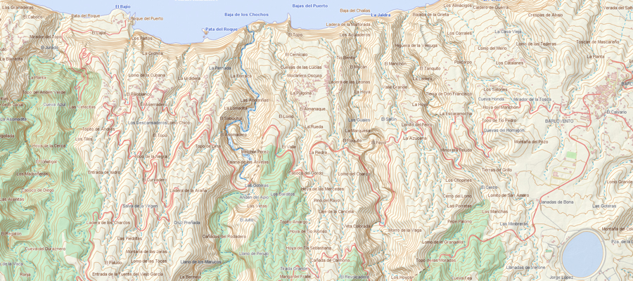
A topographic map is a detailed graphic representation of the earth’s surface showing both natural and man-made features present in an area. This type of map is differentiated by the use of contour lines, which indicate the variations in the altitude of the terrain, allowing the three-dimensional characteristics of the relief to be represented in two dimensions. For a more complete explanation of what surveying is and its importance, you can visit this article on the definition and uses of surveying. Characteristics of a topographic map Topographic maps have a number of unique characteristics that make them indispensable for certain activities. Among the most outstanding are: Contour lines: Lines connecting points with the same altitude. These curves allow to visualize the shape of the terrain, being key to understand if an area is flat or mountainous. The closer the lines are together, the steeper the terrain. Symbology: Symbols and colors are used to represent natural elements (such as rivers and mountains) and man-made elements (such as roads and buildings). Each symbol has a specific and standard meaning. Scale: Scale defines the relationship between the map and reality. Common scales are 1:25,000 or 1:50,000, where 1 cm on the map is equivalent to 25,000 or 50,000 cm on the real terrain. What is a topographic map used for? Topographic maps have applications in many industries because of their ability to show relief accurately. Here are some of the most important uses: Infrastructure planning Before starting any construction project, engineers need to analyze the terrain. Topographic maps can identify slopes, natural obstacles and the best location for structures such as roads or buildings. This information is vital to avoid problems that may arise during construction. Geological exploration In geology and mining, topographic maps are indispensable for analyzing geological formations and planning the exploration of natural resources such as minerals or oil. These maps allow to understand the physical characteristics of the terrain before starting an excavation. Outdoor activities Topographic maps are essential for hikers, mountaineers and trekkers. They provide accurate relief information, allowing safe routes to be planned and difficult terrain to be avoided. They are also useful for guiding adventurers in remote areas without access to GPS technology. How to read a topographic map Knowing how to read a topographic map is a fundamental skill for those who need to navigate or plan in unfamiliar terrain. Here’s how to interpret it: Contour lines: The closer together they are, the steeper the terrain. Separate curves indicate flat areas. Elevations: The curves are marked with numbers indicating height above sea level, allowing easy identification of mountain elevations or depressions. Symbology: Familiarize yourself with the standard symbols that represent elements such as rivers, roads and buildings. These symbols are essential to understand the context of the map. Importance of topographic maps in planning and analysis. Topographic maps are fundamental tools in many areas of planning and analysis: Civil engineering: Used for large projects such as dams, roads or airports, where it is crucial to know the characteristics of the terrain. Natural resource management: They help plan land use and anticipate natural disasters such as floods by assessing the slope of the land and the disposition of water bodies. Education and science: Topographic maps are used in geography and geology studies to better understand how landscapes are formed and how natural forces interact with the terrain.
What is topography? Definition and its importance

Surveying is the science of measuring and describing in detail the physical characteristics of the earth’s surface. Its data is fundamental to multiple industries, such as engineering, architecture and urban planning. Through surveying, graphical representations such as maps and three-dimensional models are created, allowing the land to be understood and its use to be properly planned. For more details on what a topographic map is, its characteristics and uses, visit this article on what is a topographic map. What does surveying mean and its applications The term topography comes from the Greek words topos (place) and graphia (description). In essence, it refers to the detailed study of the characteristics of a terrain. Topography is key in mapping, infrastructure planning, and land evaluation, providing accurate data for decision making in construction and urban development projects. What is surveying responsible for? Surveying is the precise measurement of distances, heights and angles of the earth’s surface. Through these measurements, surveyors obtain fundamental data to generate maps and models that accurately describe the relief and characteristics of the terrain. These graphic representations allow engineers, architects and urban planners to work with accurate information about the area where a project will be developed. Process and tools in surveying Surveying is the first step in obtaining terrain data. This process involves the use of specialized instruments, such as the total station, which measures angles and distances, or GPS, which provides accurate coordinates. Modern tools, such as LiDAR scanners, make it possible to obtain detailed three-dimensional models that describe the surface with high accuracy, thus improving project planning and design. History of topography: From antiquity to the present day. Surveying has its roots in antiquity. The Egyptians were pioneers in employing rudimentary techniques to align the pyramids. In Rome, surveying was crucial for the construction of roads and aqueducts connecting vast regions of the Empire. Over the centuries, surveying tools have been perfected, leading to modern surveying, which combines traditional instruments with advanced technologies such as GPS and LiDAR. Types of topography There are several types of surveying, each with specific applications: Flat topography: Used for small areas, where the curvature of the Earth is not a relevant factor. Geodetic topography: Applied to large extensions of land, considering the earth’s curvature. Cadastral surveying: Focused on the measurement of land for legal and property registration purposes. Each of these types of topography is intended to provide an accurate description of the terrain, adapted to the needs of each project. The relevance of surveying in construction projects and beyond. Surveying is crucial for the planning and execution of projects in various industries. In engineering and construction, it provides the data needed to design infrastructure over terrain with complex features. An accurate topographic survey is fundamental to avoid errors in the location of structures, and in my experience, small mismatches in measurements can lead to serious problems during construction. Beyond engineering, surveying is vital in mapping, agriculture and natural resource management. Detailed measurements make it possible to plan irrigation systems, prevent flooding and optimize land use, ensuring more efficient and sustainable development. The challenges and future of surveying The use of advanced technologies, such as GPS and LiDAR scanners, has revolutionized surveying, making measurements faster and more accurate. However, this also poses challenges, such as the need to train new professionals in the use of these technological tools and limited access to advanced equipment in certain regions. As technology continues to advance, surveying is likely to become even more integrated with geographic information systems (GIS), providing more complete and detailed analyses. In short, surveying is not only essential for mapping and project planning, but also ensures that projects are carried out with maximum accuracy, minimizing risks and optimizing available resources. With technological advances, its importance will continue to grow.